")


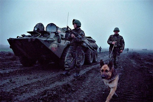
The fight "can last even a hundred years"
The Japanese authorities' rants about the desire to develop relations with Russia conflict with the affairs of the Cabinet of Ministers Yoshihide Sugi. So, according to a Japanese newspaper The Japan Times, the Ministry of Education and Science demanded to amend school textbooks on geography and social studies about the ownership of the Kuril Islands, referred to in Japan as the "northern territories".
From now on, Japanese textbooks will report, that the Kuril Islands are supposedly an integral part of Japan, and Russia "occupied" them and owns them illegally. This fully reflects the position of the Japanese government., According to the newspaper. “Textbooks should report, that Japan is making efforts to resolve territorial issues across the islands, controlled by Russia ", - notes The Japan Times.
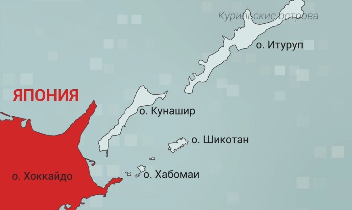
The Japanese government actually recognized the impossibility of getting from Moscow to "return" Japan to the southern islands of the Great Kuril Ridge - Kunashir and Iturup, as well as the islands of the Lesser Kuril ridge - Shikotana and Ploskie, in Japanese Habomai. Therefore, it was found expedient to start playing long. Namely, to prepare new generations of Japanese to fight the Russians..
Only do the compilers of school textbooks explain, that the Kuril Islands cannot be "natively Japanese" just because, that until the second half of the 19th century, not like the Kuriles, but also Ezo Island (Hokkaido) were not part of the Japanese state. Ezo was considered a "gaichi" - a foreign land, where did the Ainu people live, exterminated by the sons of the "divine Yamato nation". The entire Hokkaido was incorporated into the Japanese Empire only after the Meiji Revolution in 1869 year. Until this time, the Japanese lived only on the southern tip of the island., where there was a small Japanese principality Matsumae Khan.
Any reliable information about, that in the 17th century people from the Matsumae principality sailed and visited the Kuril Islands, no. it, of course, does not exclude the possibility that, that from the Ainu-Ezoos the Japanese had heard about the islands located to the north of Ezo. It was also known that, that the people inhabiting these northern lands represent the same Ainu people. It is quite acceptable even then, that the Japanese, through the Ainu Ezo, had trade contacts with the Ainu islanders. However, used by Tokyo as proof that the Kuriles belonged to Japan, the "Shoho Period Map" 1644 year could hardly have been compiled by the Japanese based on the results of the expedition to the Kuril Islands, if only because, that five years earlier, Japan had imposed a ban on leaving Japanese shores on pain of death. In addition, the "Shoho Period Map" itself is not so much a map, how much is a drawing-like plan diagram, likely, made by some Japanese without personal acquaintance with the islands, according to the stories of the Ainu. The first attempts of the Matsumae principality to establish a Japanese trading post on the island of Kunashir, closest to Ezo, relate only to 1754 g. The historical fact is that, that for the first time the Japanese, as representatives of the Japanese state, were in the southern Kuriles in 1785 year, a century and a half after the compilation of the "Shoho Period Map".
There are indications that, that the Kuriles were attributed to the Russian Empire during the reign of Anna Ioannovna. Appointing in 1730 year G. Pisarev "the head of Okhotsk", the empress determined, that the Kuril Islands are also given under his supervision and management, on whom it was necessary to continue to collect yasak from the local population.
According to Russian sources, the beginning of regular contacts between Russians and the aborigines of the South Kuril Islands dates back to the middle of the 18th century. AT 1755 g. yasak collector N. Storozhev first took tribute-yasak from part of the inhabitants of the island of Kunashir. Subsequently, the population of the Urup Islands was also levied., Iturup, Shikotan. The collection of yasak was carried out on these islands regularly until the beginning of the 80s until the royal decree on its abolition.. Russian researchers attach particular importance to this fact.. celebrated, what “At that time the collection of tribute from the local population was one of the most important conditions and at the same time a sign of citizenship of this population (and therefore, and territory belonging, where it lived) country, who received this tribute ".
Since the 1760s, Russian fishing vessels sailing to the southern Kuril Islands have become more frequent.. Here the Russians founded their winter huts and camps.. During these years, the local population of the islands of Urup and Iturup was brought into Russian citizenship.. Although merchants and tax collectors robbed the Ainu, they at the same time introduced them to civilization - taught them how to use firearms, raise livestock, grow vegetables. Missionary activity was also carried out: many Ainu were baptized and converted to Orthodoxy, and some learned to read and write and mastered the Russian language. In the second half of the 18th century, Russians continued to map the Kuril Islands, including southern. A detailed description of the Kuriles was made in 1770 g. Ivan Cherny. Also known are the maps of the southern part of the Kuril archipelago, compiled at the end of the 1770s by navigators Ivan Ocheduin and Mikhail Petushkov.. Attempts to establish contacts with residents of Ezo Island continued (Hokkaido). In the late 1770s, the ships of the merchant Antipin and other merchants reached the shores of this island..
In the 80s of the 18th century, the facts of Russian activity in the Kuril Islands were accumulated enough to, to consider the entire archipelago in accordance with the norms of international law of that time, including its southern islands, owned by Russia. This is recorded in Russian government documents.. First of all, should be called imperial decrees 1779, 1786, 1799 gg., in which the Russian citizenship of the South Kuril Ainu was confirmed (then called "furry smokers"), and the islands themselves were declared the possession of Russia. It is important to note, that the problems of the Kuriles included in the Russian Empire and the peoples inhabiting them were directly dealt with by Catherine II. There is a document from 30 April 1779 year "Decree of Catherine II to the Senate on the exemption from taxes of the population of the Kuril Islands, accepted Russian citizenship ". The decree reads: “Eya I.V. commands the shaggy smokers brought into citizenship on the distant islands to leave free and not to demand any collection from them, yes, and henceforth, the peoples living in Tamo should not be forced to do so, but try to continue the familiarity already established with them in a friendly manner and gentleness for the desired benefit in trades and trade. And besides, about all the peoples who are citizens, which live on the Kuril Islands lying from Kamchatka to the east, in the reasoning of the yasak collection from them, to examine and, following the example of the above-mentioned resolution now from her I.V.. about shaggy smokers rules make a proper definition, and what to do, notify him about it, the Attorney General, without continuation ". By decree of the Empress from 22 December 1786 g. The Collegium of Foreign Affairs of the Russian Empire was to officially declare that the lands discovered in the Pacific Ocean belonged to the Russian crown.. In pursuance of the decree, a note was drawn up in the highest name about "The announcement through the Russian ministers at the courts of all maritime European powers, that these open lands by Russia cannot be otherwise and be recognized, as belonging to your empire ". Among the territories included in the Russian Empire were also "Ridge of the Kuril Islands, concerning Japan, opened by captain Spanberg and Walton ".
About, that all the Kuril Islands, including southern, during the reign of Catherine II were part of Russia irrefutably testifies "Map of Irkutsk Governorship, consisting of 4 areas, divided into 17 counties ". All Kuril Islands on the map, including Ethorp (Iturup), Kunashir and Chikota (Shikotan), painted as the territory of the Russian Empire in the same color, as Kamchatka. The Kuril Islands in those years were administratively included in the Kamchatka district of the Okhotsk region of the Irkutsk governorship. The very same map of the Irkutsk governorship was part of the main official cartographic publication of that time - "Atlas of the Russian Empire, consisting of 52 kart, published in the city of St.. Peter in the summer of 1796 during the reign of Catherine II ". The advance of the Russians to the Kuril Islands was aimed not only at the development of these newly discovered territories, but also dictated by the interest to establish trade with Japan. Such trade was supposed to solve the problem of purchasing food for supplying it to Russian fishing expeditions and settlements in Alaska and the Pacific Islands.. At the same time, contrary to the assertions of the Dutch and other Western Europeans, the Russians did not have any hostile and even more aggressive plans against Japan.. AT 1788 g. Catherine II ordered to severely punish Russian industrialists in the Kuril Islands, that they "Did not touch the islands, under the jurisdiction of other powers ". These instructions were strictly followed, and the Russians explored the Kuriles island after island, just making sure, that their inhabitants are "autocratic".
Along with the imperial decrees, the territorial affiliation of the Kuriles was reflected, As already mentioned, on Russian geographical maps and atlases. In particular, the entire Kuril ridge up to the northern shores of Hokkaido was designated as an integral part of the Russian Empire in the Atlas for public schools of the 1780s., in the above-mentioned Atlas of the Russian Empire 1796 city, and also on the "newest geographical map of Russia" 1812 of the year.
As for Japan, then it remained a country closed to the outside world, the isolation regime lasted until the middle of the 19th century. One of the main elements of this policy was not only the ban on the departure of Japanese nationals from the country., but also the prohibition of the construction of large ships and the related policy of non-expansion of Japanese territory, preserving Japan within its medieval borders.
Japanese schoolchildren will learn none of this.. Japan's Ministry of Education and Science is tasked with convincing the next generation that, that their country allegedly owned the Tishima Islands from ancient times (Kuril), and the Russians took them away and do not want to give them away. From an early age, Japanese children are being trained to fight the Russians for the "northern islands", which "can last even a hundred years" ...
Anatoly Koshkin